Saturday, January 10, 2015

Anton Chico, NM

Anton Chico is a historical old Spanish-Mexican community settled in the 1820's when the new Mexican government issued a land grant along the Pecos River to encourage settlement in the area.  Anton Chico is located about 6 miles west of  Highway      between Interstate 40 and Las Vegas, New Mexico. 


The day I visited the Pecos River was in major flood stage and on a real rampage.


Old buildings are scattered along the banks of the Pecos River showing the evidence of long time settlement in the area dating back to early 1800's.


The cemetery in Anton Chico seems to be in two sections, old and new.
The older section is rather unkept and has graves back into the early 1800's.
 

Tuesday, January 6, 2015

Loyal Valley----Herman Lehmann

Loyal Valley is another of the small German communities north of Fredericksburg settled after about 1860.  You have to take the "Loyal Valley Bypass"  off US 87  to visit Loyal Valley.  One of its most famous
residents was Herman Lehman who was captured by the Indians when he was about 10 years old.  He lived with various tribes and grew to adulthood living with the tribes.  He rode, fought, killed, and raided right along with his Indian "brothers" until he was recaptured by US Army and returned to his family in Loyal Valley. 

There will be another post in this blog about an Indian battle between the Commanches and US Cavalry at Silver Lake in West Texas.  Herman Lehman fought alongside the Commanches in this battle against the army. 
Silver Lake is about 425 miles northwest of Loyal Valley, this will give an idea of the expanse covered by the Commanches.
 
One of the locals told me a story that his grandfather had related about Herman Lehmann.  Every year in Mason the community held a big rodeo and BBQ.  Part of the festivities was for a steer to be released in the rodeo arena and Herman Lehmann dressed in Indian garb would ride out on his horse, chase the steer, and in the same style that Commanches shot buffalo he would shoot the steer with his bow and arrow.  He would immediately jump off his horse, run over and gut the steer and pull out its liver and eat it.
The civilized gringo's would then use the steer for the BBQ event.


This two story house was built sometime around 1870 and was a stage stop on the San Antonio -El Paso Route. 


The cemetery at Loyal Valley dates to the 1870's and is still in use by families in the area.


Willie Lehman, Herman's younger brother was about 8 years old when he was captured by the Indians.   A few days later Willie was able to escape and made his way home to Loyal Valley.  Willie continued to live in Loyal Valley until his death in the 1950's


Herman Lehman Headstone


From the TSHA Handbook on Texas
 
LEHMANN, HERMAN (1859–1932). Herman Lehmann, child captive of the Apaches, son of Moritz (Maurice) and Augusta Johanna (Adams) Lehmann, German immigrants, was born on June 5, 1859, near Loyal Valley in southeastern Mason County. His parents were married in Texas in 1849; after his father died in 1864 his mother married Philipp Buchmeier (Buchmeyer) in 1866. In May 1870, when he had never been to school and spoke only German, Herman, almost eleven, and a younger brother, Willie, were captured by raiding Apaches; two younger sisters who were with them were not taken.

Willie escaped and returned home in about nine days. Herman was adopted by his Apache captor, Carnoviste, and initiated into the rigors of primitive Indian life. He underwent harsh tribal training and initiation, became a warrior, and took part in expeditions against the Texas Rangersqv, Comanches, Mexicans, and white settlers, ranging with the tribe from the Guadalupe Mountains in New Mexico down into the Mason County-San Saba region and into Mexico. After Carnoviste was killed and Lehmann himself had killed an Apache medicine man, he spent a year alone on the plains of West Texas before joining the Comanches, to whom he was known as Montechena (Montechina); he had also been called at various times En Da and Alamán.

With the Comanches he fought the Tonkawas and United States Cavalry, and he again took part in Indian raids. He was with the last Quahadi remnant that joined the reservation at Fort Sill. He was adopted by Quanah Parker but was ultimately recognized as a white captive and forced to return in May 1878 to his Texas family, who had thought him dead for the eight years he lived with the Indians.

At home he refused to eat pork or sleep in a bed, and he embarrassed his family by sometimes appearing before his mother's hotel guests with his body painted, dressed only in leggings, breech clout, and feathers. He startled a revival meeting with an Indian dance, thinking the congregation was praying for rain. His brother Willie kept him from killing the neighbors' calves and hogs and from stealing horses from adjoining farms. He relearned German, learned English, engaged in numerous odd jobs, tried for a single day to attend school, and worked as a trail driver. Although he never adjusted to white society fully, Herman did accept his role in the Loyal Valley community, and his easygoing nature and good humor seem to have made him many friends. After an unhappy earlier marriage ended in divorce, he married Miss Fannie Light in 1890, and the couple had two sons and three daughters. Later, as a Comanche, he was given Oklahoma lands by the United States government, and he spent much of his time with his red brothers.

He was a local celebrity throughout the Texas Hill Country, where he gave many public exhibitions of skill at riding, roping, and archery. In later years he met many of the Texas Rangers and soldiers he had fought against as an Indian. He died on February 2, 1932, and was buried in Loyal Valley


Lange Familly Cemetery on US HWY 87

This is one of the more unusual things I have found in my travels.  Not to far from Cherry Springs on the west side of US Highway 87 there is actually a cemetery in the bar ditch beside the highway.  The cemetery is
marked with a single vertical monument marked LANGE and is enclosed
inside a chain link fence.  There appear to be five burial locations inside the fence, each is covered with a concrete slab. 


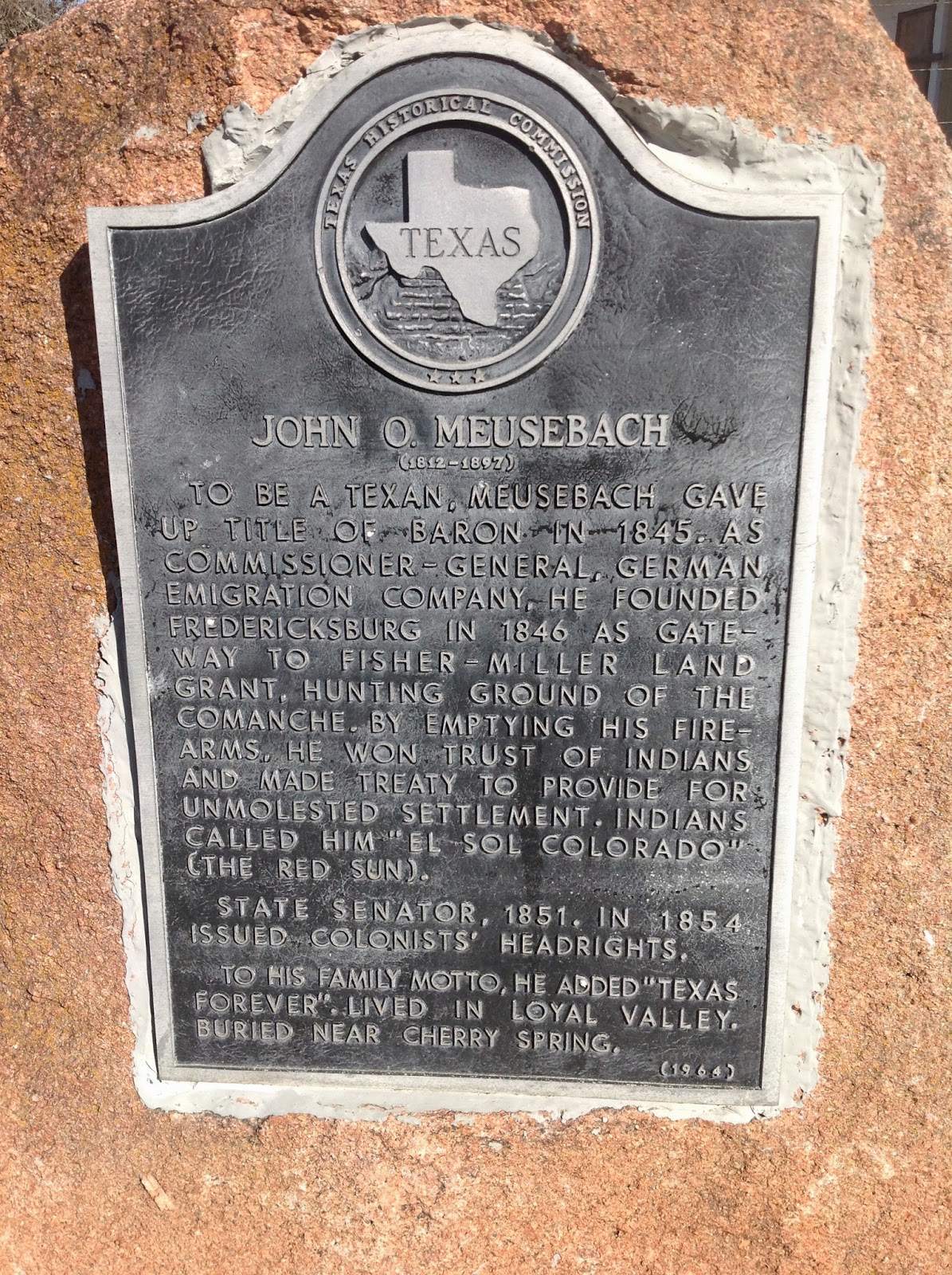
John Meusebach


John Meusebach had more influence on the settlement of central Texas in the mid 1800's than anyother individual.  He was a leader in the German settlement of the Fredericksburg area, made a peace treaty with the Commanches, and served in various govermental positions.  More than any other individual he was responsible for the settlement of the Fisher Miller
Land Grant, primarily by German immigrants.
 
Click on this website for more information on Meusebach


Cherry Springs, Gillespie County

As the German families moved north from Fredericksburg and started new
communities, schools and churches always followed.  Cherry Springs was one of the early settlements in mid 1800's


The church at Cherry Springs is an incredible stone church that was completed in 1906 and is still in use today. 


Very little remains of the community of Cherry Springs except just across the road from the church is the Diedrich Rode Complex which consists of a group of stone and wooden buildings dating to 1870's.  One of these is a three story stone building in which the lower two stories were used as a residence and the upper floor was used for a warehouse.
 
The entire area is enclosed with a tall slated fence which makes it impossible to make pictures of the complex.  I asked one of the workers that came out of the main gate if it would be possible to get pictures of the buildings.  He told me he would have to call long distance to get permission and it would take several days.....end result is no pictures.


From the Texas State Historical Association Handbook on Texas
CHERRY SPRING, TEXAS. Cherry Spring is on Cherry Spring Creek a half mile south of the Mason county line and 16½ miles northwest of Fredericksburg in northern Gillespie County. The site was originally settled by Dietrich Rode and William Kothe, who left Fredericksburg in search of land in 1852. According to some sources Rode had built a small Lutheran church at Cherry Spring in 1849 with lumber shipped from Austin. Later settlers included William Marschall, Conrad Ahrens, Ludwig Spaeth, and Adam Schneider. Cherry Spring was on the route from San Antonio to El Paso and thus enjoyed a moderate prosperity as a commercial center. A number of the early settlers were sheep ranchers. The Cherry Spring post office was established in 1858, and by 1860 the town had a population of 202, 142 of whom had German surnames. In 1897 John O. Meusebach was buried at Cherry Spring. The community's post office closed in 1912. Its population was estimated at forty in 1933 but by 1964 had fallen to nine. In the late 1960s, however, Cherry Spring grew, reaching a reported population of seventy-five by 1970.
 

Prairie Mountain School---Llano County


When the German families around Fredricksburg started to move to new areas, one of the first movements was to the north.  The Prairie Mountain area and the area surrounding Cherry Springs and Castell were some of the
first areas settled.  With settlement came the need for schools and one of the
first established was at Prairie Mountain.


The introduction of the school bus and the consolidation of school districts has led to many if not most of these old school houses being abandoned.  In
many communities they have been maintained and are now being used as
churches, "meeting houses", and community centers.


From the Texas State Historical Association webpage

PRAIRIE MOUNTAIN, TEXAS. Prairie Mountain is on Farm Road 2323 twenty miles southwest of Llano in southwestern Llano County. At the beginning of the twentieth century it was variously known as Starks, Putnam, and Hickory. When a rural school was built on Roundtree Ranch in 1906, the community took its name from the nearby Prairie Mountain. The first teacher was Martha Ward. The division of the Roundtree Ranch into smaller holdings in 1913 and 1914 increased the local population. The community of about twenty families continued to support social functions at least into the 1970s.  Prairie Mountain was still listed as a community in 1990.

Saturday, December 27, 2014

Los Almagres Mine, Lost San Saba Mine, Bowie Mine

In the 1750's the Spanish governor of Texas sent an expedition into the hill country of what is now central Texas to check on reports of rich deposits of
silver and gold.  The expedition returned with rich ore samples that started the stories, quest, and tales of vast riches.

For years the quest for these mines and vast hoards of buried treasure have sent hunters all over the area.  The Spanish built a presidio and a mission to
protect the miners and pacifiy the Indians.  The Commanches promptly
burned the mission down and killed the priests.  The hunt for the missing
mines continued, in the early 1900's the University of Texas historian Herbert E. Bolton announced that using old Spanish documents he had
located the mines on Honey Creek south east of Llano.  The USGS placed
a marker at his site.  Only problem was no mines and no treasure was located in the area.

For several years my history buddy Bill Wootan told me about a friend  he had gone to high school with that believed he had located the mines on his ranch just a few miles from the Bolton site.  James Stotts, who ranches southeast of Llano near Packsaddle Mountain, had told Bill about several "mines" they had located in the process of clearing brush off his ranch.  We tried several times to visit the site but it didn't work out until November of 2014 when Stotts gave us an inspection tour of the mines and mineshafts.
 
This is a pile of what I would call mine "tailings", the debris that was removed from the mine shaft.  The debris was sorted into three different piles as it was removed.  Small gravel and rocks, larger material, and finally large rocks.
 
 
It is very obvious from the size of these rocks that some serious mining operations went on at this site.


This is the first mine shaft we visited.  It is a vertical shaft that is about 8 feet in diameter and has water standing in it at about the 40 foot level.  It has been covered with mesh wire to prevent livestock from falling into it.
 
 
Another view of mineshaft #1


Mineshaft #2 is a horizontal tunnel that goes back into the side of the hill.
 
Again, the large size of the rocks removed shows evidence of some serious digging


Another vertical mineshaft


This shaft is one of the largest and most impressive.  Our buddy Stanley Miller is standing in the mine opening to give a perspect of the size of
the mine opening.  This shaft is about 200 feet long horizontally and has a couple of vertical shafts that are up to 60 feet deep.  No pictures from inside, I don't do tunnels or mines or caves.


These mines are located in extremely rough and brushy country.  It is so rugged that ranchers are unable to run cattle on the rangeland and resort to raising goats.  One of the reasons that the mine sites went undisovered for so long is that they are covered by the brush on the terrain.  It was only when the Stotts family started using a bulldozer to clear brush that they discovered the mine shafts.


Here is the reason I don't do tunnels and mines.  Bill Wootan placed it in the permanent relocation program


A geologist friend told us that one of the indications of gold and silver was the presence of red streaks (iron) found in quartz deposits.  Rocks like this cover the area around the various mine shafts.


Another long horizontal mine shaft


Another horizontal mine shaft.  It is easy to see why with all the heavy brush and growth that these sites went undetected for so long.


Bill Spain stands beside the outer wall of a large stone corral near the mine shafts.  This corral is about 50 x 50 feet, rock walls on three sides and the vertical mountain side forms the fourth side.